
Contents
- 1 Nevado de Toluca Trail (Mexico)
- 2 Pico de Orizaba (Citlaltépetl) Trail (Mexico)
- 3 Barrancas del Cobre Trails (Mexico)
- 4 Acatenango Volcano Trail (Guatemala)
- 5 Cerro de la Muerte Trail (Costa Rica)
- 6 Santa Ana Volcano Trail (El Salvador)
- 7 Volcán Barú Trail (Panama)
- 8 Victoria Peak Trail (Belize)
- 9 Pico Bonito National Park Trails (Honduras)
- 10 Mombacho Volcano Trails (Nicaragua)
- 11 Inca Trail (Peru)
- 12 Torres del Paine Circuit (Chile)
- 13 Cocuy National Park Trails (Colombia)
Latin America, a land of dramatic landscapes and rich biodiversity, offers some of the most breathtaking mountain trails in the world.
From the snow-capped peaks of the Andes to the lush cloud forests of Central America, this diverse region invites hikers to explore its hidden wonders on foot.
Whether you’re an experienced trekker in search of high-altitude challenges or a nature lover seeking scenic routes through ancient ruins and vibrant ecosystems, Latin America’s trails promise unforgettable adventures.
Nevado de Toluca Trail (Mexico)
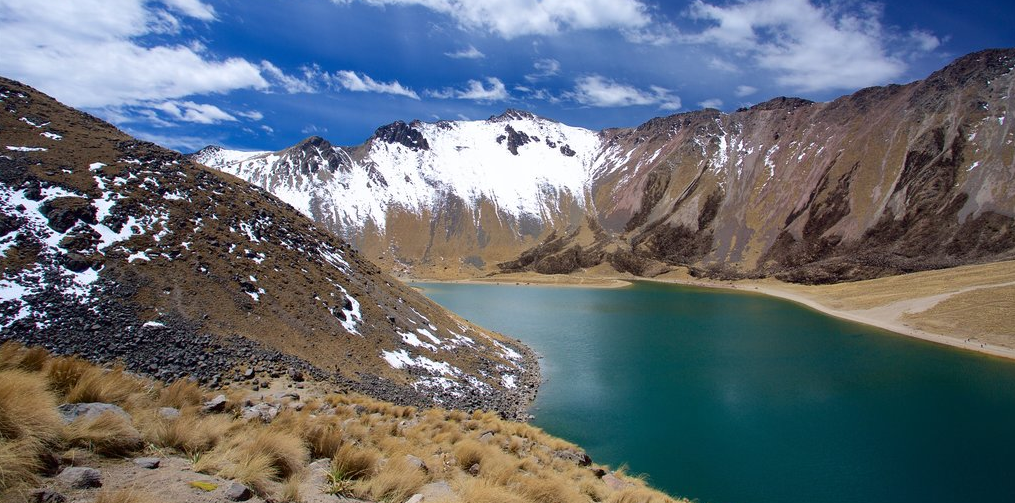
Located in the State of Mexico, Nevado de Toluca, also known as Xinantécatl, stands as one of Mexico’s most iconic and geologically fascinating peaks. Its hiking trails provide a captivating journey into a world of unique geophysical traits and unparalleled natural beauty.
Geophysical Traits
The Nevado de Toluca Trail traverses a mesmerizing landscape marked by extraordinary geophysical features:
Volcanic Origins: As the fourth-highest peak in Mexico, Nevado de Toluca is a dormant stratovolcano. It boasts two prominent crater lakes, known as the “Sun” and “Moon” lagoons, which are among the highest in the world.
Alpine Tundra: Hikers will ascend through diverse ecological zones, starting in dense forests of pine and fir trees and reaching the high alpine tundra characterized by barren volcanic rock and vibrant patches of moss and lichen.
Crater Lakes: The “Sun” and “Moon” lagoons, which fill the caldera of the volcano, showcase strikingly contrasting colors: the “Sun” lagoon presents turquoise hues, while the “Moon” lagoon shimmers with deep blue tones.
Dramatic Peaks: The trail leads to the summit of Nevado de Toluca, offering panoramic vistas of the surrounding mountains and valleys, including the nearby Pico de Orizaba, Mexico’s highest peak.
Pico de Orizaba (Citlaltépetl) Trail (Mexico)
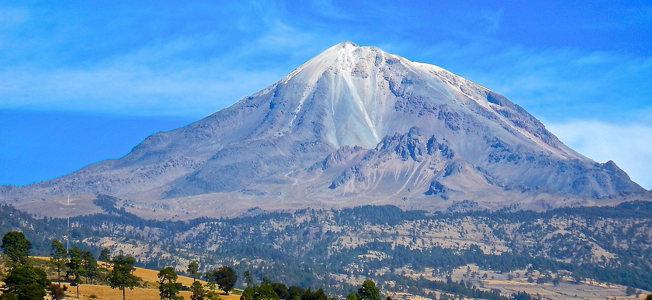
Rising majestically along the border of the Mexican states of Puebla and Veracruz, Pico de Orizaba, known locally as Citlaltépetl, stands as Mexico’s highest peak. The Pico de Orizaba trail offers an exhilarating and geographically unique adventure for hikers.
Geophysical Traits
The Pico de Orizaba trail traverses a dynamic and visually captivating landscape, characterized by exceptional geophysical features:
Volcanic Origins: Pico de Orizaba is a stratovolcano and the tallest volcano in North America. Its towering presence, reaching 18,491 feet (5,636 meters) above sea level, draws hikers from around the world.
Glacial Zones: As hikers ascend, they transition through diverse ecological zones, from dense forests to alpine meadows, ultimately reaching the glaciated region near the summit.
Permanent Snow Cap: Pico de Orizaba features a permanent snow cap and several glaciers, including the Jamapa Glacier, which adds a striking contrast to the rocky volcanic slopes.
Crater and Inner Crater: The volcano’s summit offers a mesmerizing view of its main crater, showcasing the dramatic interplay of ice, rock, and the inner crater, making it a geological wonder.
Volcanic Rock Formations: Hikers will navigate through fields of volcanic boulders, some of which are ancient, and others are remnants of past eruptions.
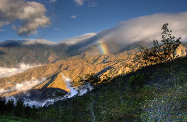
Barrancas del Cobre Trails (Mexico)
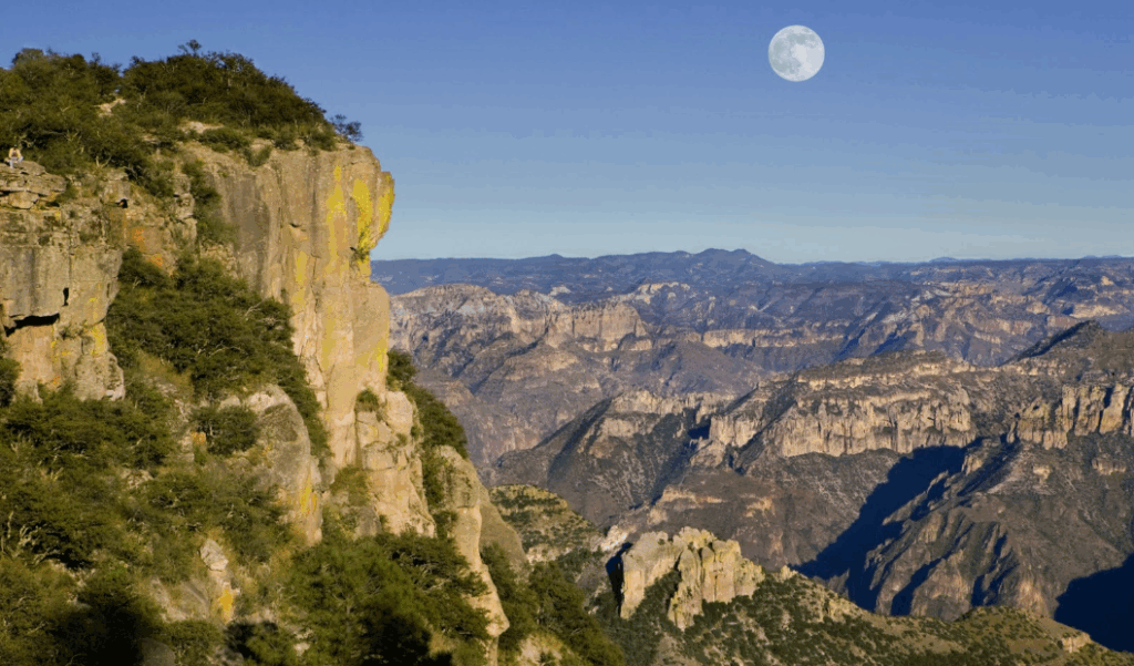
Tucked away in the heart of northern Mexico, the Barrancas del Cobre (Copper Canyons) are a network of dramatic canyons that rival the Grand Canyon in sheer magnitude and beauty.
These canyons, along with their intricate trail systems, are a hidden gem for hikers seeking an adventure into the heart of Mexico’s rugged landscapes.
Geophysical Traits
The Barrancas del Cobre trails traverse a diverse and geographically fascinating landscape, characterized by an array of remarkable features:
Canyon System: The Barrancas del Cobre comprise six major canyons that interlace and overlap, creating a vast network of deep chasms and towering cliffs. These canyons are collectively deeper than the Grand Canyon in the United States.
Rock Formations: Hikers will encounter stunning rock formations, from towering cliffs to delicate spires and mesas, each carved by the forces of erosion.
Rugged Terrain: The trails meander through a rugged, challenging landscape, with steep ascents and descents, rocky paths, and cliffside trails.
Diverse Ecosystems: As hikers explore different elevations within the canyons, they will encounter a variety of ecosystems, from high-altitude pine forests to subtropical valleys.
Waterfalls and Rivers: The canyons are home to a number of pristine rivers and cascading waterfalls, providing refreshing spots to rest and take in the surroundings.
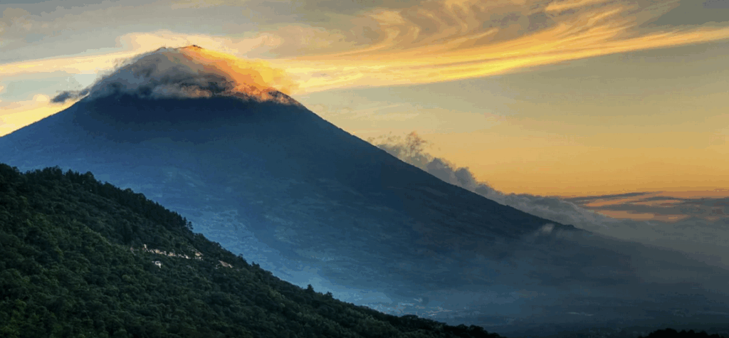
Acatenango Volcano Trail (Guatemala)
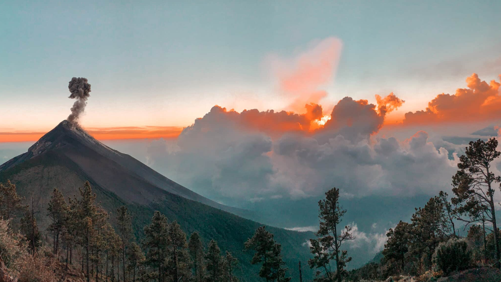
Guatemala’s rugged landscapes are home to a treasure trove of volcanic wonders, and Acatenango Volcano stands tall as one of the most thrilling and geologically fascinating peaks.
The Acatenango Volcano trail beckons intrepid hikers to embark on a journey into a world of geological marvels, offering remarkable geophysical traits and attractions that make it a must-visit for adventure seekers.
Geophysical Traits
Acatenango’s volcanic realm is marked by a series of captivating geophysical features:
Twin Peaks: Acatenango is part of a complex volcanic system with two main peaks: Pico Mayor and Yepocapa, both showcasing their own distinctive characteristics.
Stratovolcano Structure: Acatenango is a stratovolcano, defined by its conical shape and layers of hardened lava and volcanic ash, displaying the restless geological history of the region.
Lava Fields: Hikers will traverse vast lava fields, some still showing signs of the volcano’s most recent eruptions, offering a thrilling and slightly otherworldly experience.
Volcanic Ash and Cinder Cones: Along the trail, you’ll encounter volcanic ash and cinder cones, which are a testament to the volcano’s explosive past.
Fuego’s Fury: One of the most compelling traits of Acatenango is its proximity to Volcán de Fuego, an active volcano. From the summit, hikers can witness the awe-inspiring spectacle of Fuego’s eruptions, creating an unforgettable natural fireworks show.
Cerro de la Muerte Trail (Costa Rica)
Nestled in the heart of Costa Rica’s lush Central Valley, the Cerro de la Muerte trail presents a captivating journey into the rugged landscapes of this enchanting country.
Boasting unique geophysical traits and an array of natural attractions, this trail offers a thrilling experience for hikers seeking adventure and connection with the natural world.
Geophysical Traits
The Cerro de la Muerte trail traverses a dynamic and visually stunning landscape, defined by remarkable geophysical features:
High Mountain Splendor: Cerro de la Muerte, which translates to “Mount of Death,” is the highest point on the Inter-American Highway. At an elevation of over 11,000 feet (3,451 meters), it ranks among Costa Rica’s tallest peaks.
Cloud Forest Ecosystems: Hikers will wander through lush cloud forests, characterized by dense fog, moss-covered trees, and a diverse array of plants, some of which are endemic to the region.
Volcanic Lava Flows: The trail passes through areas that were shaped by volcanic activity, with exposed lava flows and volcanic rocks adding a dramatic touch to the landscape.
Biodiversity Hotspot: Cerro de la Muerte is home to a variety of unique flora and fauna, including resplendent quetzals, hummingbirds, and a wide range of orchids.
Distinct Microclimates: Hikers will experience diverse microclimates, from cool and misty cloud forests to sunny alpine meadows, each providing distinct geophysical traits and natural beauty.
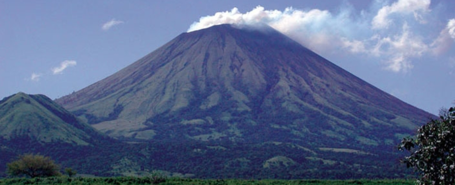
Santa Ana Volcano Trail (El Salvador)
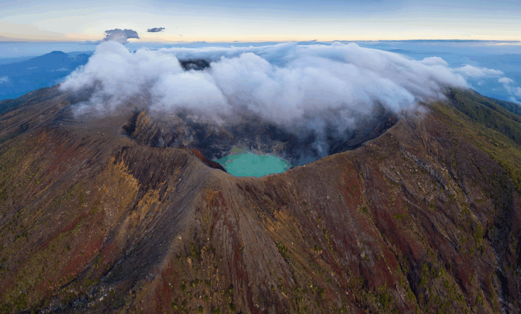
In the heart of El Salvador, the Santa Ana Volcano, locally known as Ilamatepec, beckons adventurers to embark on a thrilling journey through rugged landscapes and geological wonders.
The Santa Ana Volcano trail offers hikers a chance to explore unique geophysical traits while connecting with the powerful forces of nature.
Geophysical Traits
The Santa Ana Volcano trail leads through a dynamic and visually stunning landscape marked by unique geophysical features:
Stratovolcano Beauty: Santa Ana is a stratovolcano, characterized by its majestic conical shape. It’s the highest volcano in El Salvador and one of the most prominent in Central America.
Crater Lake: At the summit of Santa Ana, hikers are rewarded with a view of a serene, emerald-green crater lake known as Lake Coatepeque, adding a touch of tranquility to the otherwise dynamic volcano.
Sulfurous Vents: Along the trail, hikers may encounter sulfurous vents, showcasing the volcano’s continuing activity and geological significance.
Rock Formations: The landscape is adorned with dramatic rock formations, including ancient lava flows and ash deposits, painting a picture of the volcano’s geological past.
Diverse Ecosystems: As hikers ascend through different elevations, they will witness a variety of ecosystems, from lush forests to rocky alpine meadows, each with its own charm.
Volcán Barú Trail (Panama)
Panama’s enchanting landscapes boast more than just pristine beaches and lush rainforests. The Volcán Barú trail beckons hikers to explore the nation’s geological wonders, ascending to the highest point in the country.
This trail offers a mesmerizing journey through unique geophysical traits and natural beauty, making it a must-visit for adventurers seeking a taste of Panama’s high-altitude wilderness.
Geophysical Traits
The Volcán Barú trail leads hikers through a dynamic landscape that is marked by a variety of geophysical features:
Volcanic Ascent: Volcán Barú is Panama’s only volcano, a stratovolcano with a distinctive conical shape that hints at its explosive geological history.
Panoramic Vistas: As hikers ascend, they’ll be treated to breathtaking vistas of Panama’s diverse landscapes, including both the Pacific and Atlantic Oceans.
Cooler Climates: The trail takes hikers from Panama’s tropical lowlands to cooler high-altitude climates, with distinct ecosystems found along the way.
Crater Exploration: At the summit, hikers can explore the expansive Barú Crater and its surroundings, offering unique geophysical insights.
Biodiversity: The hike introduces hikers to a variety of flora and fauna, including high-altitude cloud forests and diverse wildlife.
Victoria Peak Trail (Belize)
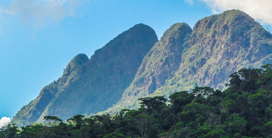
Belize, renowned for its pristine rainforests and turquoise waters, harbors a hidden gem in its interior – the Victoria Peak trail.
This trail offers intrepid hikers the chance to explore unique geophysical traits while venturing into one of the country’s most captivating and biologically diverse landscapes.
Geophysical Traits
The Victoria Peak trail takes hikers through a landscape defined by captivating geophysical features:
Ancient Mountain: Victoria Peak is Belize’s second-highest mountain, with a peak elevation of approximately 3,675 feet (1,120 meters). It’s part of the Maya Mountains range, showcasing its ancient geological history.
Karst Terrain: The trail winds through karst terrain, marked by limestone formations, caves, and underground rivers, giving the landscape a rugged, otherworldly appearance.
Lush Rainforest: Hikers will journey through lush and biodiverse rainforests, experiencing the heart of Belize’s remarkable ecosystems.
Waterfalls and Rivers: The trail is dotted with pristine rivers, cascading waterfalls, and natural pools that offer rejuvenating spots for rest and reflection.
Unique Flora and Fauna: The area around Victoria Peak is renowned for its rich biodiversity, home to rare species like the elusive jaguar and the resplendent quetzal, making it a paradise for wildlife enthusiasts.
Pico Bonito National Park Trails (Honduras)
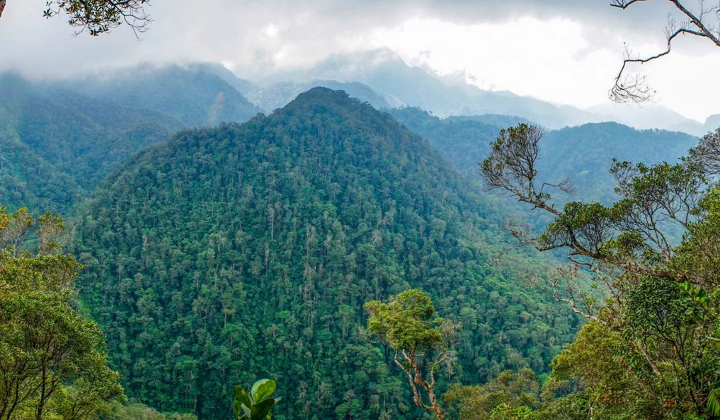
Nestled in the heart of Honduras, the Pico Bonito National Park beckons nature enthusiasts and adventure seekers to explore its unspoiled beauty.
The park’s network of hiking trails offers a unique opportunity to uncover geophysical wonders while immersing yourself in the rich biodiversity of the region.
Geophysical Traits
The Pico Bonito National Park trails lead hikers through a captivating landscape marked by distinct geophysical features:
Majestic Mountain: The park’s namesake, Pico Bonito, is a prominent peak that reaches an elevation of approximately 7,742 feet (2,359 meters). It’s a defining geophysical feature of the area.
Karst Topography: The park’s terrain is characterized by karst topography, showcasing limestone formations, caves, and underground rivers, creating a unique and rugged environment.
Lush Rainforests: Hikers will journey through lush tropical rainforests, home to a rich array of plant and animal species. The park is part of the Mesoamerican Biological Corridor, emphasizing its ecological significance.
River Systems: Numerous rivers, such as the Cangrejal River, flow through the park, offering picturesque scenes, opportunities for refreshing swims, and exciting white-water rafting experiences.
Biodiversity: Pico Bonito is renowned for its high biodiversity, with a variety of wildlife, including jaguars, ocelots, tapirs, and numerous bird species, making it a haven for wildlife enthusiasts.
Mombacho Volcano Trails (Nicaragua)
Nicaragua, known for its stunning landscapes and volcanic terrain, harbors a hidden treasure within the cloud forests of Mombacho Volcano.
The Mombacho Volcano trails invite intrepid explorers to discover the unique geophysical traits and captivating beauty of this region.
Geophysical Traits
The Mombacho Volcano trails lead hikers through a mesmerizing landscape defined by distinct geophysical features:
Stratovolcano Form: Mombacho Volcano is a stratovolcano, characterized by its majestic conical shape and prominent volcanic crater.
Cloud Forests: Hikers traverse lush cloud forests, enveloped in mist and adorned with moss-covered trees, creating a unique and enchanting environment.
Crater Lake: The summit of Mombacho is graced with a pristine crater lake, Laguna de Mombacho, offering a serene and reflective spot for hikers to unwind.
Sulfur Vents: Along the trails, hikers may encounter active sulfur vents, which provide a glimpse into the volcano’s geological activity and ancient history.
Biodiversity Haven: Mombacho Volcano is renowned for its rich biodiversity, with a variety of plant and animal species, some of which are endemic to the region.
Inca Trail (Peru)
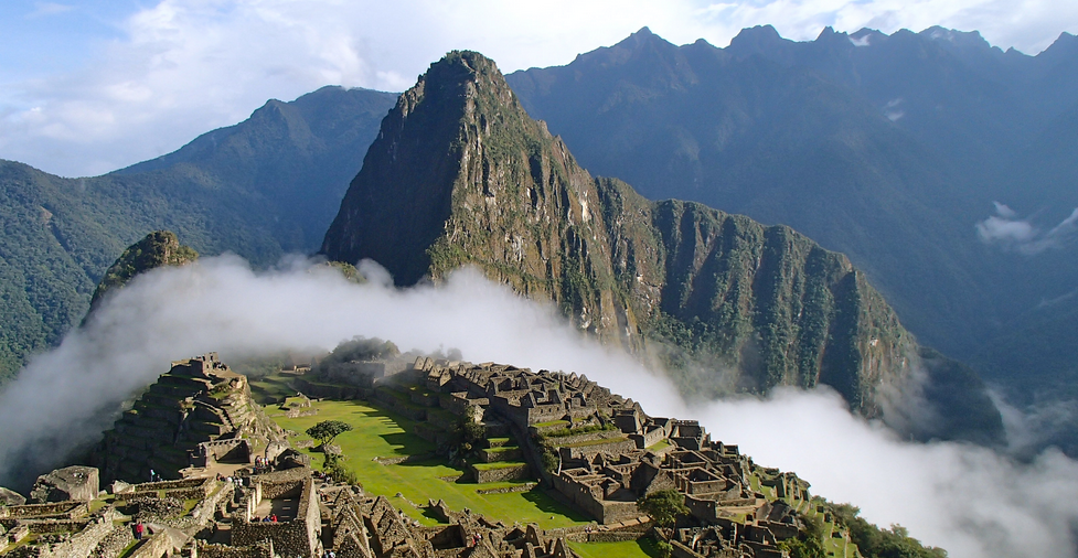
Nestled within the picturesque Andes Mountains of Peru, the legendary Inca Trail offers a passage to a bygone era while leading modern-day adventurers through breathtaking landscapes and rich historical tapestries.
This ancient footpath, adorned with geological marvels and cultural treasures, serves as an emblematic route that captivates hikers seeking both a physical challenge and a historical pilgrimage.
Geophysical Traits
Andean Mountain Vistas: The trail traverses through diverse Andean landscapes, showcasing rugged mountain terrain, cloud forests, and high-altitude plains.
Ancient Stone Pathways: Hikers follow original Incan stone pathways, witnessing the architectural ingenuity of ancient civilizations, including cobblestone steps and walls.
Archaeological Sites: En route, the trail is adorned with enigmatic Incan ruins like Wiñay Wayna and Intipata, echoing the ancient civilization’s architectural and engineering prowess.
Tropical Cloud Forests: The trail winds through lush, misty cloud forests, adorned with a rich diversity of flora and fauna, including orchids, hummingbirds, and unique plant species.
Torres del Paine Circuit (Chile)
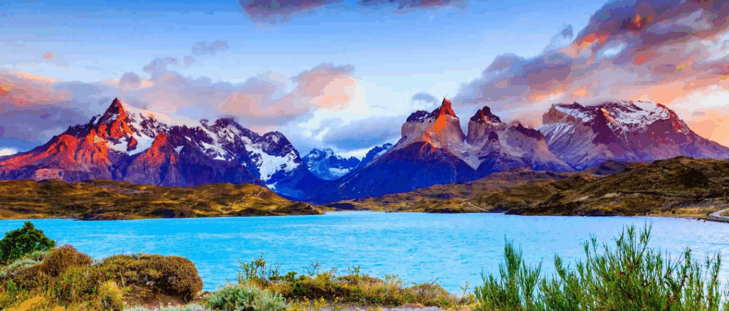
Nestled in the southern reaches of Chilean Patagonia, the Torres del Paine Circuit is an epic trekking circuit that draws adventurers seeking an immersive encounter with nature’s grandeur.
This revered network of trails weaves through diverse geophysical terrains, showcasing breathtaking landscapes and offering a blend of ecological and cultural attractions that captivate and challenge hikers.
Geophysical Traits
Granite Spires: Towering granite peaks, including the iconic Torres del Paine, pierce the sky, creating a dramatic backdrop against the Chilean Patagonian landscape.
Glaciers and Ice Fields: Glaciers and ice fields punctuate the terrain, captivating hikers with their icy allure and offering glimpses of Patagonia’s glacial legacy.
Pristine Lakes and Rivers: The trail winds around sparkling lakes, azure and emerald in hue, adding serenity and scenic beauty to the landscape.
Vast Grasslands: Expansive grasslands known as pampas, home to guanacos and foxes, contribute to the varied ecological tapestry of the region.
Cocuy National Park Trails (Colombia)
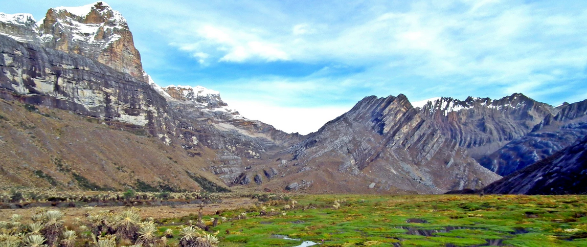
Nestled within the rugged Andes of Colombia, Cocuy National Park stands as an alpine paradise, inviting intrepid hikers to venture through a stunning array of geophysical traits and natural wonders.
This hiker’s haven boasts an assortment of trails that weave through awe-inspiring landscapes, promising both breathtaking vistas and a glimpse into Colombia’s diverse ecosystem.
Geophysical Traits
Snow-Capped Peaks: The park hosts an array of snow-capped mountains, including Ritacuba Blanco, the highest peak, and numerous glacial formations decorating the skyline.
Paramo Ecosystem: Hikers trek through the unique paramo ecosystem, characterized by high-altitude plains, unique vegetation, and highland shrubs.
Crystal-Clear Lakes: The trails lead to serene, crystal-clear glacial lakes nestled amidst the mountains, offering tranquil and reflective spots along the hike.
Rock Formations: Unique rock formations and geological marvels, formed over centuries, dot the landscape, adding a sense of wonder to the hiking experience.